Kivas Tully to Walt Whitman, 4 August 1880
 man_ej.00155_large.jpg
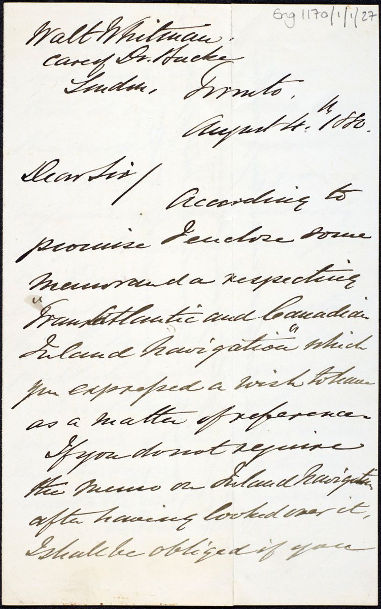
Walt Whitman
care of Dr. Bucke
London, Toronto,
August 4th, 1880.
Dear Sir/
man_ej.00155_large.jpg
Walt Whitman
care of Dr. Bucke
London, Toronto,
August 4th, 1880.
Dear Sir/
According to promise I enclose some memoranda respecting "TransAtlantic and Canadian Inland Navigation" which you expressed a wish to have as a matter of reference.1
If you do not require the news on Inland Navigation after having looked over it, I
shall be obliged if you 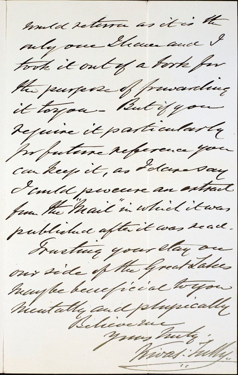 man_ej.00227_large.jpgwould return as it is the only one I have and I took it out
of a book for the purpose of forwarding it to you—But if you require it
particularly for future reference you can keep it, as I dare say I could procure
an extract from the "Mail" in which it was published after it was read.
man_ej.00227_large.jpgwould return as it is the only one I have and I took it out
of a book for the purpose of forwarding it to you—But if you require it
particularly for future reference you can keep it, as I dare say I could procure
an extract from the "Mail" in which it was published after it was read.
Trusting your stay on our side of the Great Lakes may be beneficial to you mentally and physically
Believe me Yours truly, Kivas Tully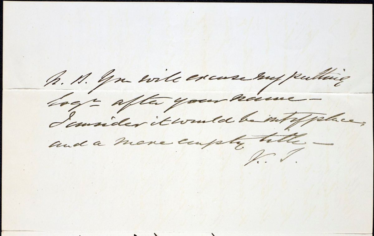 man_ej.00228_large.jpg
P.S. You will excuse my putting Esqr after your name—I consider it would be out of place; and a mere empty title—
K. T.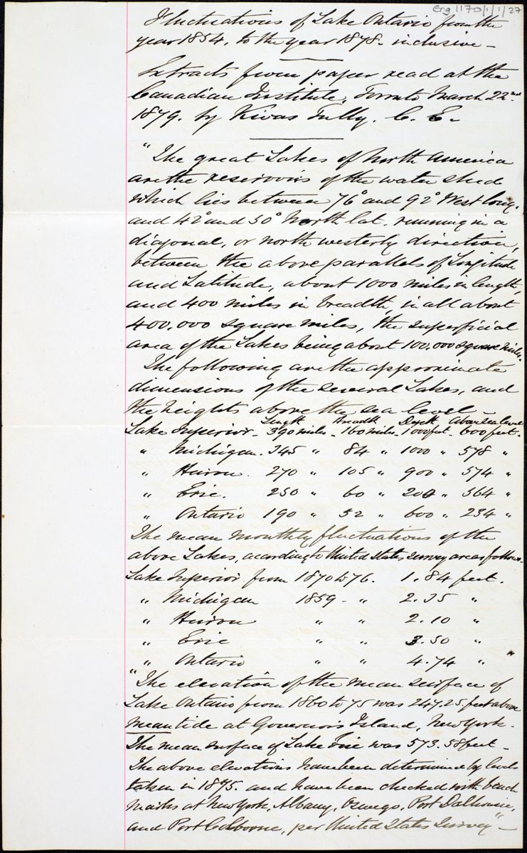 man_ej.00158_large.jpg
Fluctuations of Lake Ontario from the year 1854, to the
year 1878, inclusive—
Extracts from paper read at the Canadian
Institute, Toronto March 22nd 1879. by Kivas
Tully, C. E.
"The great Lakes of North America are the reservoirs of the water shed which lies between 76° and 92° West long. and 42° and 50° north lat. running in a diagonal, or north westerly direction, between the above parallels of Longitude and Latitude, about 1000 miles in length, and 400 miles in breadth, in all about 400,000 square miles, the superficial area of the Lakes being about 100,000 square miles.
The following are the approximate dimensions of the several Lakes, and the heights above the sea level—
| Length | Breadth | Depth | Above sea level | |
| Lake Superior— | 390 miles— | 160 miles— | 1000 feet— | 600 feet— |
| " Michigan. | 245 " | 84 " | 1000 " | 578 " |
| " Huron. | 270 " | 105 " | 900 " | 574 " |
| " Erie. | 250 " | 60 " | 200 " | 564 " |
| " Ontario | 190 " | 52 " | 600 " | 234 " |
The mean monthly fluctuations of the above Lakes, according to the United States survey are as follows.
| Lake Superior from | 1870 to 76. | 1.84 feet. |
| " Michigan | 1859 - " | 2.05 " |
| " Huron | " " | 2.10 " |
| " Erie | " " | 3.50 " |
| " Ontario | " " | 4.74 " |
"The elevation of the mean surface of Lake Ontario from 1860 to 75 was 247.25 feet above mean tide at Governor's Island, New York. The mean surface of Lake Erie was 573.58 feet—The above elevations have been determined by levels taken in 1875, and have been checked with beach marks at New York, Albany, Oswego, Port Dalhousie, and Port Colborne, per United States Survey"—
 man_ej.00160_large.jpg
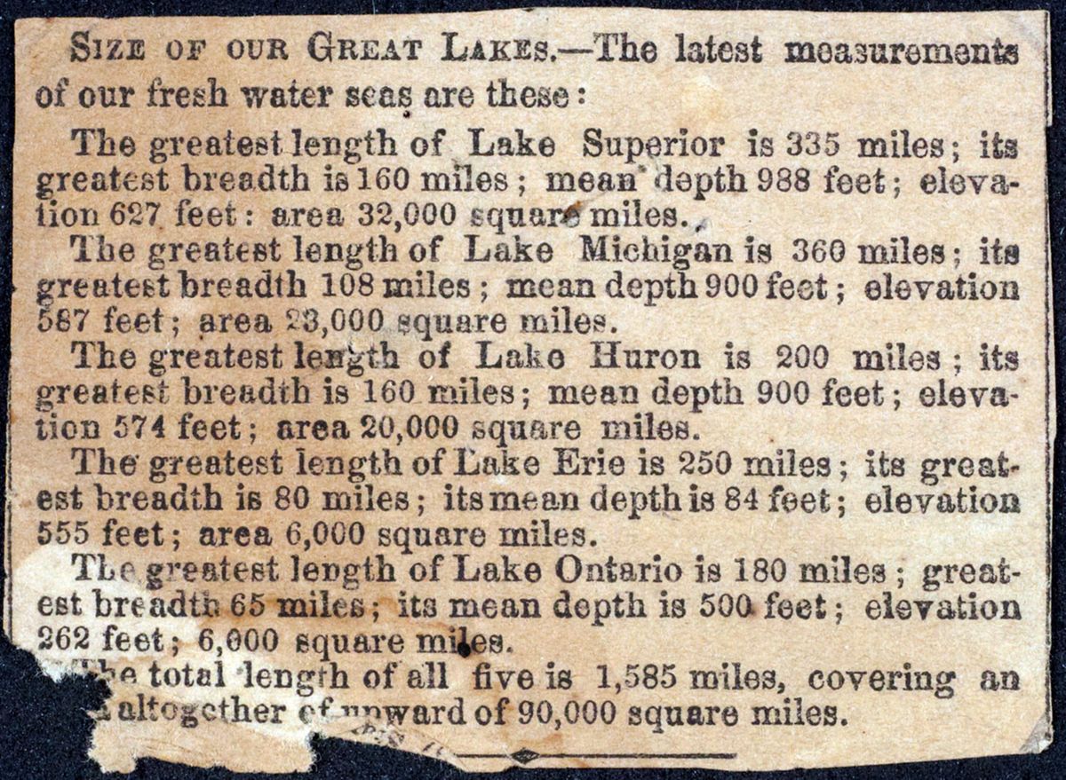
SIZE OF OUR GREAT LAKES.—
The latest measurements of our fresh water seas are these:
The greatest length of Lake Superior is 335 miles; its greatest breadth is 160 miles; mean depth 988 feet; elevation 627 feet: area 32,000 square miles.
The greatest length of Lake Michigan is 360 miles; its greatest breadth 108 miles; mean depth 900 feet; elevation 587 feet; area 23,000 square miles.
The greatest length of Lake Huron is 200 miles; its greatest breadth is 160 miles; mean depth 900 feet; elevation 574 feet; area 20,000 square miles.
The greatest length of Lake Erie is 250 miles; its greatest breadth is 80 miles; its mean depth is 84 feet; elevation 555 feet; area 6,000 square miles.
The greatest length of Lake Ontario is 180 miles; greatest breadth 65 miles; its mean depth is 500 feet; elevation 262 feet; 6,000 square miles.
The total length of all five is 1,585 miles, covering an [are]a altogether of upward of 90,000 square miles.
 man_ej.00161_large.jpg
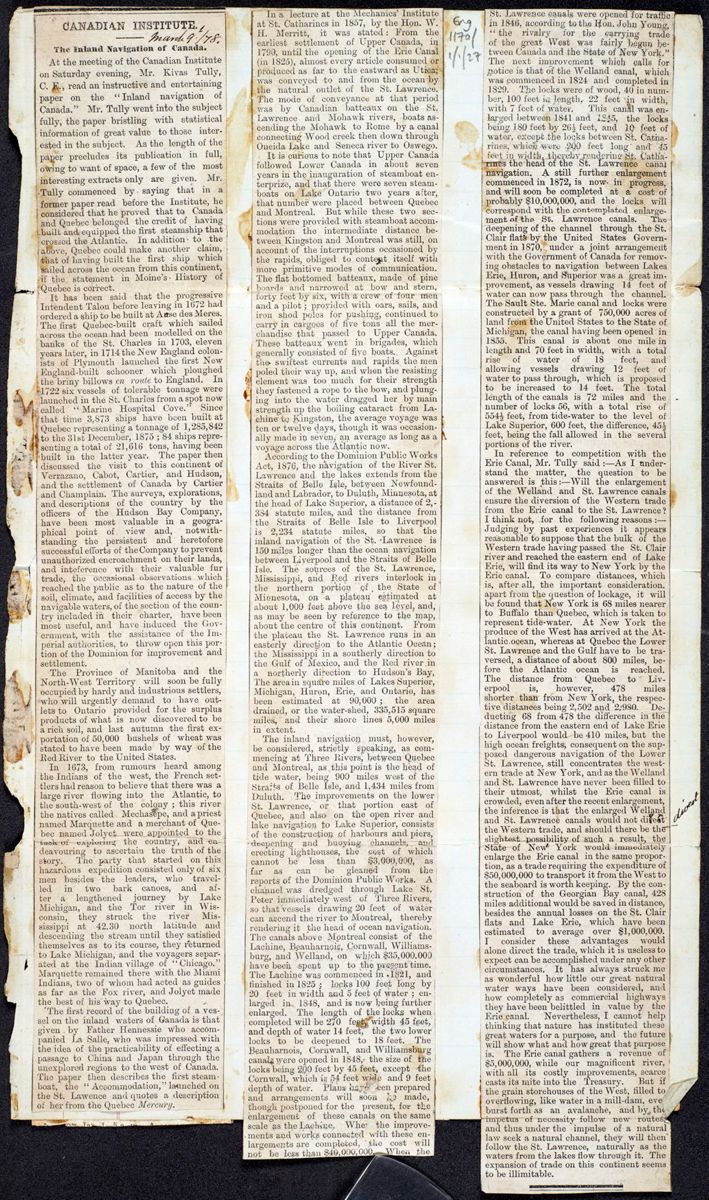
CANADIAN INSTITUTE.2
The Inland Navigation of Canada.
At the meeting of the Canadian Institute on Saturday evening, Mr. Kivas Tully, C. E., read an instructive and entertaining paper on the "Inland navigation of Canada." Mr. Tully went into the subject fully, the paper bristling with statistical information of great value to those interested in the subject. As the length of the paper precludes its publication in full, owing to want of space, a few of the most interesting extracts only are given. Mr. Tully commenced by saying that in a former paper read before the Institute, he considered that he proved that to Canada and Quebec belonged the credit of having built and equipped the first steamship that crossed the Atlantic. In addition to the above, Quebec could make another claim, that of having built the first ship which sailed across the ocean from this continent, if the statement in Moine's History of Quebec is correct.
It has been said that the progressive Intendent Talon before leaving in 1672 had ordered a ship to be built at Anse des Meres. The first Quebec-built craft which sailed across the ocean had been modelled on the banks of the St. Charles in 1703, eleven years later, in 1714 the New England colonists of Plymouth launched the first New England-built schooner which ploughed the briny billows en route to England. In 1722 six vessels of tolerable tonnage were launched in the St. Charles from a spot now called "Marine Hospital Cove." Since that time 3,873 ships have been built at Quebec representing a tonnage of 1,285,842 to the 31st December, 1875; 84 ships representing a total of 21,616 tons, having been built in the latter year. The paper then discussed the visit to this continent of Verrazano, Cabot, Cartier, and Hudson, and the settlement of Canada by Cartier and Champlain. The surveys, explorations, and descriptions of the country by the officers of the Hudson Bay Company, have been most valuable in a geographical point of view and, notwithstanding the persistent and heretofore successful efforts of the Company to prevent unauthorized encroachment on their lands, and inteference with their valuable fur trade, the occasional observations which reached the public as to the nature of the soil, climate, and facilities of access by the navigable waters, of the section of the country included in their charter, have been most useful, and have induced the Government, with the assistance of the Imperial authorities, to throw open this portion of the Dominion for improvement and settlement.
The Province of Manitoba and the North-West Territory will soon be fully occupied by hardy and industrious settlers, who will urgently demand to have outlets to Ontario provided for the surplus products of what is now discovered to be a rich soil, and last autumn the first exportation of 50,000 bushels of wheat was stated to have been made by way of the Red River to the United States.
In 1673, from rumours heard among the Indians of the west, the French settlers had reason to believe that there was a large river flowing into the Atlantic, to the south-west of the colony; this river the natives called Mechasepe, and a priest named Marquette and a merchant of Quebec named Jolyet were appointed to the task of exploring the country, and endeavouring to ascertain the truth of the story. The party that started on this hazardous expedition consisted only of six men besides the leaders, who travelled in two bark canoes, and after a lengthened journey by Lake Michigan, and the Tor river in Wisconsin, they struck the river Mississippi at 42.30 north latitude and descending the stream until they satisfied themselves as to its course, they returned to Lake Michigan, and the voyagers separated at the Indian village of "Chicago." Marquette remained there with the Miami Indians, two of whom had acted as guides as far as the Fox river, and Jolyet made the best of his way to Quebec.
The first record of the building of a vessel on the inland waters of Canada is that given by Father Hennessie who accompanied La Salle, who was impressed with the idea of the practicability of effecting a passage to China and Japan through the unexplored regions to the west of Canada. The paper then describes the first steamboat, the "Accommodation," launched on the St. Lawence and quotes a description of her from the Quebec Mercury.
In a lecture at the Mechanics' Institute at St. Catharines in 1857, by the Hon. W. H. Merritt, it was stated: From the earliest settlement of Upper Canada, in 1790, until the opening of the Erie Canal (in 1825), almost every article consumed or produced as far to the eastward as Utica, was conveyed to and from the ocean by the natural outlet of the St. Lawrence. The mode of conveyance at that period was by Canadian batteaux on the St. Lawrence and Mohawk rivers, boats ascending the Mohawk to Rome by a canal connecting Wood creek then down through Oneida Lake and Seneca river to Oswego.
It is curious to note that Upper Canada followed Lower Canada in about seven years in the inauguration of steamboat enterprize , and that there were seven steamboats on Lake Ontario two years after, that number were placed between Quebec and Montreal. But while these two sections were provided with steamboat accommodation the intermediate distance between Kingston and Montreal was still, on account of the interruptions occasioned by the rapids, obliged to content itself with more primitive modes of communication. The flat bottomed batteaux, made of pine boards and narrowed at bow and stern, forty feet by six, with a crew of four men and a pilot; provided with oars, sails, and iron shod poles for pushing, continued to carry in cargoes of five tons all the merchandise that passed to Upper Canada. These batteaux went in brigades, which generally consisted of five boats. Against the swiftest currents and rapids the men poled their way up, and when the resisting element was too much for their strength they fastened a rope to the bow, and plunging into the water dragged her by main strength up the boiling cataract from Lachine to Kingston, the average voyage was ten or twelve days, though it was occasionally made in seven, an average as long as a voyage across the Atlantic now.
According to the Dominion Public Works Act, 1876, the navigation of the River St. Lawrence and the lakes extends from the Straits of Belle Isle, between Newfoundland and Labrador, to Duluth, Minnesota, at the head of Lake Superior, a distance of 2,384 statute miles, and the distance from the Straits of Belle Isle to Liverpool is 2,234 statute miles, so that the inland navigation of the St. Lawrence is 150 miles longer than the ocean navigation between Liverpool and the Straits of Belle Isle. The sources of the St. Lawrence, Mississippi, and Red rivers interlock in the northern portion of the State of Minnesota, on a plateau estimated at about 1,000 feet above the sea level, and, as may be seen by reference to the map, about the centre of this continent. From the plateau the St. Lawrence runs in an easterly direction to the Atlantic Ocean; the Mississippi in a southerly direction to the Gulf of Mexico, and the Red river in a northerly direction to Hudson's Bay, The area in square miles of Lake Superior, Michigan, Huron, Erie, and Ontario, has been estimated at 90,000; the area drained, or the water-shed, 335,515 square miles, and their shore lines 5,000 miles in extent.
The inland navigation must, however, be considered, strictly speaking, as commencing at Three Rivers, between Quebec and Montreal, as this point is the head of tide water, being 900 miles west of the Straits of Belle Isle, and 1,434 miles from Duluth. The improvements on the lower St. Lawrence, or that portion east of Quebec, and also on the open river and lake navigation to Lake Superior, consists of the construction of harbours and piers, deepening and buoying channels, and erecting lighthouses, the cost of which cannot be less than $3,000,000, as far as can be gleaned from the reports of the Dominion Public Works. A channel was dredged through Lake St. Peter immediately west of Three Rivers, so that vessels drawing 20 feet of water can ascend the river to Montreal, thereby rendering it the head of ocean navigation. The canals above Montreal consist of the Lachine, Beauharnois, Cornwall, Williamsburg, and Welland, on which $35,000,000 have been spent up to the present time. The Lachine was commenced in 1821, and finished in 1825; locks 100 feet long by 20 feet in width and 5 feet of water; enlarged in 1848, and now being further enlarged. The length of the locks when completed will be 270 feet, width 45 feet, and depth of water 14 feet, the two lower locks to be deepened to 18 feet. The Beauharnois, Cornwall, and Williamsburg canals were opened in 1848, the size of the locks being 200 feet by 45 feet, except the Cornwall, which is 54 feet wide and 9 feet depth of water. Plans have been prepared and arrangements will soon be made, though postponed for the present, for the enlargement of these canals on the same scale as the Lachine. When the improvements and works connected with these enlargements are completed, the cost will not be less than $40,000,000. When the St. Lawrence canals were opened for traffic in 1846, according to the Hon. John Young, "the rivalry for the carrying trade of the great West was fairly begun between Canada and the State of New York." The next improvement which calls for notice is that of the Welland canal, which was commenced in 1824 and completed in 1829. The locks were of wood, 40 in number, 100 feet in length, 22 feet in width, with 7 feet of water. This canal was enlarged between 1841 and 1845, the locks being 180 feet by 26½ feet, and 10 feet of water, except the locks between St. Catharines, which were 200 feet long and 45 feet in width, thereby rendering St. Catharines the head of the St. Lawrence canal navigation. A still further enlargement commenced in 1872, is now in progress, and will soon be completed at a cost of probably $10,000,000 and the locks will correspond with the contemplated enlargement of the St. Lawrence canals. The deepening of the channel through the St. Clair flats by the United States Government in 1870, under a joint arrangement with the Government of Canada for removing obstacles to navigation between Lakes Erie, Huron, and Superior was a great improvement, as vessels drawing 14 feet of water can now pass through the channel. The Sault Ste. Marie canal and locks were constructed by a grant of 750,000 acres of land from the United States to the State of Michigan, the canal having been opened in 1855. This canal is about one mile in length and 70 feet in width, with a total rise of water of 18 feet, and allowing vessels drawing 12 feet of water to pass through, which is proposed to be increased to 14 feet. The total length of the canals is 72 miles and the number of locks 56, with a total rise of 554½ feet, from tide-water to the level of Lake Superior, 600 feet, the difference, 45½ feet, being the fall allowed in the several portions of the river.
In reference to competition with the Erie Canal, Mr. Tully said:—As I understand the matter, the question to be answered is this:—Will the enlargement of the Welland and St. Lawrence canals ensure the diversion of the Western trade from the Erie canal to the St. Lawrence? I think not, for the following reasons:—Judging by past experiences it appears reasonable to suppose that the bulk of the Western trade having passed the St. Clair river and reached the eastern end of Lake Erie, will find its way to New York by the Erie canal. To compare distances, which is, after all, the important consideration, apart from the question of lockage, it will be found that New York is 68 miles nearer to Buffalo than Quebec, which is taken to represent tide-water. At New York the produce of the West has arrived at the Atlantic ocean, whereas at Quebec the Lower St. Lawrence and the Gulf have to be traversed, a distance of about 800 miles, before the Atlantic ocean is reached. The distance from Quebec to Liverpool is, however, 478 miles shorter than from New York, the respective distances being 2,502, and 2,980. Deducting 68 from 478 the difference in the distance from the eastern end of Lake Erie to Liverpool would be 410 miles, but the high ocean freights, consequent on the supposed dangerous navigation of the Lower St. Lawrence, still concentrates the western trade at New York, and as the Welland and St. Lawrence have never been filled to their utmost, whilst the Erie canal is crowded, even after the recent enlargement, the inference is that the enlarged Welland and St. Lawrence canals would not divert the Western trade, and should there be the slightest possibility of such a result, the State of New York would immediately enlarge the Erie canal in the same proportion, as a trade requiring the expenditure of $50,000,000 to transport it from the West to the seaboard is worth keeping. By the construction of the Georgian Bay canal, 428 miles additional would be saved in distance, besides the annual losses on the St. Clair flats and Lake Erie, which have been estimated to average over $1,000,000. I consider these advantages would alone direct the trade, which it is useless to expect can be accomplished under any other circumstances. It has always struck me as wonderful how little our great natural water ways have been considered, and how completely as commercial highways they have been belittled in value by the Erie canal. Nevertheless, I cannot help thinking that nature has instituted these great waters for a purpose, and the future will show what and how great that purpose is. The Erie canal gathers a revenue of $5,000,000, while our magnificent river, with all its costly improvements, scarce casts its mite into the Treasury. But if the grain storehouses of the West, filled to overflowing, like water in a mill-dam, ever burst forth as an avalanche, and by the impetus of necessity follow new routes, and thus under the impulse of a natural law seek a natural channel, they will then follow the St. Lawrence, naturally as the waters from the lakes flow through it. The expansion of trade on this continent seems to be illimitable.
 man_ej.00162_large.jpg
THE CHICAGO TRIBUNE: Tuesday, January 1,
1878
man_ej.00162_large.jpg
THE CHICAGO TRIBUNE: Tuesday, January 1,
1878
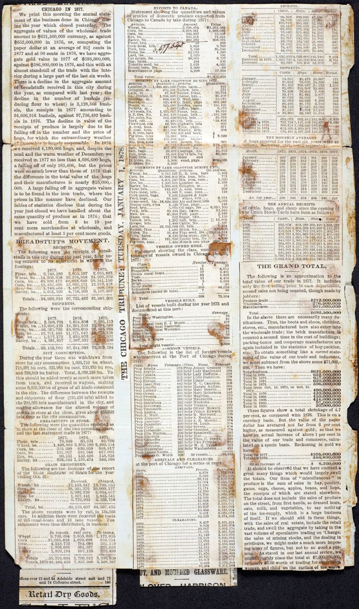
CHICAGO IN 1877.
We print this morning the annual statement of the business done in Chicago during the year which closed yesterday. The aggregate of values of the wholesale trade amount to $621,500,000 currency, as against $652,000,000 in 1876, or, computing the paper dollar at an average of 95¾ cents in 1877 and at 90 cents in 1876, we have aggregate gold value in 1877 of $595,000,000, against $586,800,000 in 1876, and this with an almost standstill of the trade with the interior during a large part of the last six weeks. There is a decline in the aggregate amount of breadstuffs received in this city during the year, as compared with last year; the decline in the number of bushels (reducing flour to wheat) is 3,128,566 bushels, the receipts in 1877 amounting to 94,606,916 bushels, against 97,736,482 bushels in 1876. The decline in value of the receipts of produce is largely due to the falling off in the number and the price of hogs, for which the extraordinary weather of December is largely responsible. In 1876 we received 4,190,006 hogs, and, despite the mud and the warm weather of December, we received in 1877 no less than 4,026,600 hogs, a falling off of only 163,406, but the prices were so much lower than those of 1876 that the difference in the total value of the hogs and their manufactures is nearly $25,000,000. A large falling off in aggregate values is to be found in the iron trade, where the prices in like manner have declined. Our tables of statistics disclose that during the year just closed we have handled about the same quantity of produce as in 1876; that we have sold from 8 to 10 per cent more merchandise at wholesale, and manufactured at least 5 per cent more goods.
BREADSTUFFS MOVEMENT.
RECEIPTS.
The following were the receipts of breadstuffs in this city during the past year, flour being reduced to its equivalent in wheat in the footings:
| 1877. | 1876. | 1875. | |
| Flour, brls ... | 2,749,180 | 2,955,197 | 2,625,883 |
| Wheat, bu ... | 14,350,658 | 16,574,058 | 24,206,370 |
| Corn, bu | 46,306,473 | 48,668,640 | 28,341,150 |
| Oats, bu | 13,432,095 | 13,030,121 | 12,916,428 |
| Rye, bu | 1,740,530 | 1,447,917 | 699,583 |
| Barley, bu | 5,031,260 | 4,716,360 | 3,107,297 |
| Totals.. . | 94,606,916 | 97,735,482 | 81,087,302 |
SHIPMENTS.
The following were the corresponding shipments:
| 1877. | 1876. | 1875. | |
| Flour, brls . .. | 2,568,724 | 2,634,838 | 2,285,113 |
| Wheat, bu . .. | 15,096,123 | 14,361,950 | 23,184,349 |
| Corn, bu .... | 46,532,795 | 45,629,035 | 26,443,884 |
| Oats, bu ..... | 12,721,435 | 11,271,642 | 10,279,134 |
| Rye, bu . .... | 1,577,172 | 1,433,976 | 310,592 |
| Barley, bu ... | 4,381,857 | 2,687,932 | 1,868,206 |
| Totals.. . | 93,153,002 | 87,241,306 | 72,369,194 |
CITY CONSUMPTION.
During the year there was withdrawn from store for city consumption 1,095,710 bu wheat, 718,391 bu corn, 325,988 bu oats, 220,350 bu rye, and 728,819 bu barley. Total, 3,089,258 bu . To this should be added nearly as much more taken from track, and received in wagons, making some 6,000,000 bu of grain of all kinds consumed in the city. The difference between the receipts and shipments of flour (180,456 brls ) added to the 290,000 brls manufactured in the city, and making allowance for the altered volume of stocks in store at the close, gives about 455,938 brls flour as the city consumption.
BREADSTUFFS IN STORE.
The following were the quantities reported as in store at the close of the two preceding years, and the last statement made in 1877:
| 1877. | 1876. | 1875. | |
| Flour, brls ........ | 78,049 | 63,531 | 62,760 |
| Wheat, bu ......... | 1,406,686 | 3,370,189 | 2,280,254 |
| Corn, bu . .. ...... | 523,290 | 930,958 | 568,817 |
| Oats, bu .......... | 151,927 | 583,244 | 417,902 |
| Rye, bu . .......... | 90,251 | 159,490 | 148,654 |
| Barley, bu ........ | 628,544 | 1,136,474 | 340,166 |
GRAIN REGISTERED.
The following are the footings of the report of the Sate Registrar of Grain for the year ending Oct. 31:
| Received. | Shipped. | ||
| Wheat, bu | ............. . | 12,163,647 | 13,748,352 |
| Corn, bu | ................. | 38,563,376 | 39,909,127 |
| Oats, bu | .......... | 5,262,210 | 5,664,657 |
| Rye, bu | ................... | 1,807,441 | 1,845,541 |
| Barley, bu | ........ ....... | 2,779,933 | 3,239,758 |
| --------- | --------- | ||
| Total, bu | .............. | 60,576,607 | 64,507,435 |
The above receipts were by rail, in 134,103 cars. In addition there were received the loads of 915 canal-boats and 13 lake vessels. The shipments were thus distributed, in bushels:
| In | |||
| In vessels. | In rail cars. | To teams. | |
| Wheat ......... | 9,720,604 | 2,855,693 | 1,172,055 |
| Corn ........... | 37,985,033 | 1,070,888 | 853,214 |
| Oats........... | 4,518,752 | 784,686 | 361,219 |
| Rye ........... | 1,326,081 | 391,527 | 227,933 |
| Barley ..... .... | 1,820,194 | 697,126 | 722,438 |
| ---------- | ---------- | ---------- | |
| Totals .. | 55,370,664 | 5,799,912 | 3,336,859 |
| Totals, 1876 | 48,186,419 | 7,857,089 | 3,508,387 |
EXPORTS TO CANADA.
Statement showing the quantities and values of articles of domestic produce exported from Chicago to Canada by lake during 1877:
| Articles. | Amount. | Value. |
| Wheat, bu ......................... | 2,738,874 | $3,262,582 |
| Corn, bu .......................... | 2,918,341 | 1,386,658 |
| Oats, bu .......................... | 192,237 | 55,666 |
| Rye, bu ..... | 135,911 | 71,951 |
| Barley, bu | 492,2823 | 208,075 |
| Flour, brls ..... | 59 | 368 |
| Corn-meal, brls ..... | 5,823 | 3,763 |
| Pork, brls ..... | 2,333 | 31,049 |
| Hams, lbs..... | 12,012 | 1,299 |
| Lard,lbs..... | 2,020 | 191 |
| Cut meats, lbs..... | 98,001 | 8,727 |
| Hay, bales..... | 234 | 300 |
| Timothy seed, bu ..... | 2,628 | 4,025 |
| Broom-corn, lbs..... | 1,500 | 68 |
| Miscellaneous pkgs ..... | 2,938 | 17,904 |
| ----------- | ||
| Total value..... | ....... | $5,052,626 |
RECEIPTS BY LAKE COASTWISE DURING 1877.
| Articles. | Quantities. |
| Lumber, ft .... | 1,009,445,000 |
| Shingles, m.. | 472,531 |
| Lath, m..... | 47,941 |
| Sq . Timber, ft | 1,096,000 |
| Heading, m.. | 666,000 |
| Staves, m..... | 125,410 |
| Hoops, m..... | 165,000 |
| Pickets, m... | 1,295 |
| Ce'r posts, No. | 1,573,027 |
| R.R. ties. No. | 1,301,118 |
| Tel. poles, No. | 112,229 |
| Bark, cds ..... | 46,495 |
| Firewood, cds | 68,709 |
| A. coal, tons. | 447,300 |
| B. coal, tons. | 352,666 |
| R.R. iron, bars | 27,650 |
| Pig iron, tons | 33,091 |
| Mis. iron, bdls | 105,649 |
| Mis. iron, tons | 3,592 |
| Iron ore, tons | 89,131 |
| Salt, brls ..... | 807,997 |
| Salt, bags..... | 29,837 |
| Salt, tons..... | 16,394 |
| Fish, brls ..... | 117,178 |
| D. hides, No.. | 5,368 |
| G. hides, No.. | 6,569 |
| Pelts, bales... | 455 |
| Tallow, brls .. | 571 |
| Butter, frkns . | 33,734 |
| Cheese, bxs ... | 25,408 |
| D. fruit, brls .. | 25,075 |
| G. fruit, pkgs | 682,345 |
| Berries, cases | 166,195 |
| Coffee, bags.. | 8,273 |
| Flour, brls ... | 18,810 |
| Sugar, brls ... | 151,598 |
| Sirup, brls .... | 31,073 |
| Oil, brls ..... | 14,436 |
| Highwi's, brls | 692 |
| Wine, pkgs .. | 871 |
| Whisky, brls . | 354 |
| Ale and beer, brls ...... . | 2,929 |
| Agr. implements, No.. | 361 |
| Grocer's pkgs | 174,289 |
| Stoves, No... | 13,975 |
| Castings, No. | 15,212 |
| Em'ty brls , No | 40,389 |
| Mdse and sund , pkgs .. | 996,586 |
SHIPMENTS BY LAKE COASTWISE DURING 1877.
| Articles. | Quantities. |
| Wheat, bu ....... | 8,212,127 |
| corn, bu ......... | 35,099,302 |
| Oats, bu ......... | 4,901,240 |
| Rye, bu ......... | 1,260,565 |
| Barley, bu ....... | 1,200,416 |
| Flour, brls ...... | 142,427 |
| Corn-meal, brls .. | 15,848 |
| Corn-meal, bags. | 7,566 |
| Feed, bags....... | 99,566 |
| Grass-seed, bls.. | 18,629,393 |
| Broom-corn, o'les | 4,128 |
| Beef, brls ........ | 5,073 |
| Pork, brls ....... | 59,194 |
| Malt, bu ......... | 45,654 |
| Hams, trcs....... | 922 |
| Tallow, brls ..... | 1,292 |
| Grease, brls ..... | 1,489 |
| Lard, lbs........ | 22,152,060 |
| Butter, frkns ..... | 1,093 |
| Hides, no....... | 35,404 |
| Pelts, bales..... | 8,120 |
| Wool, lbs...... . | 161,766 |
| Pig-iron, tons.... | 1,494 |
| R.R. iron, bars | 2,462 |
| Mis. iron, bdls .. | 772 |
| Mis. iron, tons.. | 1,020 |
| Lumber, m...... | 1,338 |
| Shingles, m..... | 16 |
| A. coal, tons... | 938 |
| B. coal, tons.... | 118 |
| Liquors & high-wines, brls | 2,373 |
| Ale and beer, brls | 5,076 |
| Wine, pkgs ...... | 148 |
| Oil cakes, lbs.... | 6,051,700 |
| Hay, bales......... | 11,945 |
| Fish, pkgs ....... | 2,548 |
| Sugar, brls ....... | 7,128 |
| Salt, brls ....... | 13,909 |
| Cattle, No...... | 1,497 |
| Oil, brls | 7,764 |
| Brick, No....... | 127,400 |
| Flax-seed. lbs... | 29,114,814 |
| Bldg stone, cds . | 3,015 |
| Empty brls , No. | 4,106 |
| Mdse & sun. pkgs | 580,955 |
VESSELS OWNED HERE.
Statement showing the class, number, and tonnage of vessels owned in Chicago Dec. 31, 1877:
| Class. | Number. | Tonnage. |
| Steamers | 2 | 33 |
| Propellers | 15 | 4,912 |
| Steam canal-boats | 27 | 2,491 |
| Tugs | 62 | 1,863 |
| Barks | 13 | 4,486 |
| Brigs | 3 | 1,016 |
| Sloop-yacht | 1 | 23 |
| Schooners | 259 | 56,022 |
| Schooners (under 20 tons) | 7 | 88 |
| --- | ------- | |
| Total | 389 | 72,934 |
VESSELS BUILT.
List of vessels built during the year 1875 and documented at this port:
| Name. | Tonnage. |
| Prop Lady Washington ... | 76 |
| Prop Pet ... | 10 |
| Steam canal-boat B. J. Moore ... | 107 |
| Steam canal-boat Nashotah ... | 94 |
| Steam canal-boat Welcome ... | 94 |
| Schr Clara ... | 11 |
| Schr Edna ... | 38 |
| Schr R. B. Hayes ... | 669 |
| ----- | |
| Total (eight vessels) ... | 1,099 |
FOREIGN VESSELS.
The following is the list of foreign vessels which arrived at the Port of Chicago during 1877:
| Class. | Name | Tonnage. |
| Prop | Acadia.... | 373 |
| Prop | Argyle.... | 355 |
| Prop | Canada .... | 353 |
| Prop | Clinton .... | 292 |
| Prop | Europe .... | 307 |
| Prop | Isaac May .... | 492 |
| Prop | Lincoln .... | 378 |
| Prop | Lothair .... | 351 |
| Prop | Ocean .... | 491 |
| Prop | Prussia .... | 301 |
| Prop | Scotia .... | 300 |
| Prop | Shickluna .... | 362 |
| Prop | Sovereign .... | 301 |
| Prop | Tecumseh .... | 543 |
| Prop | Arabia .... | 313 |
| Prop | A. Muir .... | 340 |
| Prop | Albacore .... | 361 |
| Prop | Antelope .... | 387 |
| Prop | Bangalore .... | 330 |
| Prop | Clyde .... | 358 |
| Prop | Corisande .... | 287 |
| Prop | Ella Murton .... | 229 |
| Prop | Emerald .... | 314 |
| Prop | Gleneffer .... | 367 |
| Prop | Grimsby .... | 331 |
| Prop | Hercules .... | 240 |
| Prop | Hyderabad .... | 292 |
| Prop | James Norris .... | 320 |
| Prop | James G. Worts | 308 |
| Prop | Jennie Graham | 362 |
| Schr | Lady Macdonald | 284 |
| Schr | Lady Dufferin .. | 356 |
| Schr | Lillie Hamilton. | 278 |
| Schr | Lisgar .... | 384 |
| Schr | M. C. Cameron. | 308 |
| Schr | Maggie McRae. | 395 |
| Schr | Mary Merritt ... | 347 |
| Schr | Mary Robertson | 243 |
| Schr | Magellan .... | 370 |
| Schr | Manzanilla .... | 370 |
| Schr | Muskoka .... | 454 |
| Schr | Niagara .... | 220 |
| Schr | Oliver Mowatt. | 295 |
| Schr | Prince Edward. | 123 |
| Schr | R. Morwood .... | 268 |
| Schr | S. Neelon .... | 304 |
| Schr | S. R. Merritt ... | 374 |
| Schr | St. Louis .... | 334 |
| Schr | Severn .... | 454 |
| Schr | Shandon .... | 374 |
| Schr | Speedwell .... | 182 |
| Schr | Star .... | 200 |
| Schr | Thos. C. Street. | 326 |
| Schr | Two Friends .... | 262 |
| Schr | W. R. Taylor ... | 322 |
| Schr | Waubashene ... | 451 |
| ------- | ||
| 56 vessels .... | 18,616 |
ARRIVALS AND CLEARANCES at the port of Chicago for a series of years:
ARRIVALS.
| Years. | Vessels. | Tonnage. |
| 1863 | 8,678 | 2,172,644 |
| 1864 | 8,938 | 2,172,866 |
| 1865 | 10,112 | 2,106,859 |
| 1866 | 11,084 | 2,258,572 |
| 1867 | 12,230 | 2,588,527 |
| 1868 | 13,174 | 2,984,591 |
| 1869 | 13,730 | 3,123,400 |
| 1870 | 12,739 | 3,049,285 |
| 1871 | 12,330 | 3,093,101 |
| 1872 | 12,824 | 3,059,752 |
| 1873 | 11,858 | 3,225,911 |
| 1874 | 10,827 | 3,195,633 |
| 1875 | 10,488 | 3,122,004 |
| 1876 | 9,621 | 3,089,072 |
| 1877 | 10,233 | 3,274,332 |
CLEARANCES.
| 1863 | 8,457 | 2,161,221 |
| 1864 | 8,824 | 2,166,904 |
| 1865 | 10,067 | 2,092,276 |
| 1866 | 11,115 | 2,361,520 |
| 1867 | 12,140 | 2,512,676 |
| 1868 | 13,225 | 3,020,812 |
| 1869 | 13,872 | 3,149,946 |
| 1870 | 12,433 | 2,983,942 |
| 1871 | 12,312 | 3,082,235 |
| 1872 | 12,531 | 3,017,790 |
| 1873 | 71,876 | 3,338,803 |
| 1874 | 10,720 | 3,134,078 |
| 1875 | 10,607 | 3,157,051 |
| 1876 | 9,628 | 3,078,264 |
| 1877 | 10,284 | 3,311,083 |
RECEIPTS.
| Cattle. | Hogs. | Sheep. | Horses. | |
| January | 96,318 | 359,695 | 43,586 | 151 |
| February | 94,598 | 243,932 | 37,399 | 859 |
| March | 103,518 | 255,381 | 32,935 | 1,775 |
| April | 93,410 | 316,816 | 28,286 | 1,110 |
| May | 93,869 | 272,304 | 19,582 | 853 |
| June | 78,046 | 321,492 | 14,216 | 762 |
| July | 64,012 | 255,584 | 10,782 | 458 |
| August | 82,711 | 242,431 | 19,788 | 350 |
| September | 96,073 | 242,588 | 21,986 | 440 |
| October | 91,842 | 334,657 | 26,995 | 397 |
| November | 74,407 | 499,800 | 28,701 | 390 |
| December | 64,051 | 681,970 | 26,484 | 325 |
| ------- | ------- | ------- | ------- | |
| Total | 1,032,855 | 4,026,600 | 310,740 | 7,874 |
| Received in 1876 | 1,096,745 | 4,190,006 | 364,095 | 8,159 |
| Decrease | 63,890 | 163,406 | 53,355 | 285 |
SHIPMENTS.
| Cattle. | Hogs. | Sheep. | Horses. | |
| January | 54,651 | 46,473 | 23,667 | 171 |
| February | 61,994 | 79,020 | 24,396 | 646 |
| March | 85,102 | 109,487 | 25,132 | 1,516 |
| April | 81,070 | 161,593 | 19,895 | 900 |
| May | 75,299 | 78,602 | 7,109 | 802 |
| June | 55,415 | 82,442 | 3,877 | 633 |
| July | 46,053 | 85,060 | 581 | 308 |
| August | 51,070 | 96,236 | 7,288 | 324 |
| September | 60,466 | 87,172 | 6,716 | 341 |
| October | 54,153 | 79,843 | 10,658 | 338 |
| November | 41,510 | 48,834 | 12,235 | 278 |
| December | 38,300 | 58,150 | 11,354 | 182 |
| ------- | ------- | ------- | ------- | |
| Total | 699,083 | 952,912 | 152,908 | 6,439 |
| Shipped in 1876 | 797,724 | 1,131,635 | 195,925 | 6,839 |
| Shipped in 1875 | 696,534 | 1,582,643 | 243,604 | ....... |
| Shipped in 1874 | 622,929 | 2,330,361 | 180,555 | ....... |
| Shipped in 1873 | 574,181 | 2,197,557 | 115,235 | ....... |
THE MONTHLY AVERAGES
of hogs received for the past six years were as follows, December, 1877, being estimated:
| Month. | 1872. | 1873. | 1874. | 1875. | 1876. | 1877. |
| January | 287 | 290 | 253 | 261 | 281 | 253 |
| February | 264 | 270 | 212 | 251 | 262 | 257 |
| March | 228 | 221 | 202 | 217 | 220 | 239 |
| April | 225 | 213 | 198 | 207 | 217 | 231 |
| May | 223 | 218 | 200 | 210 | 228 | 223 |
| June | 227 | 230 | 207 | 218 | 233 | 231 |
| July | 234 | 232 | 208 | 223 | 234 | 237 |
| August | 233 | 236 | 208 | 222 | 242 | 238 |
| September | 258 | 241 | 209 | 230 | 246 | 243 |
| October | 264 | 252 | 222 | 239 | 256 | 252 |
| November | 272 | 268 | 244 | 256 | 262 | 265 |
| December | 283 | 270 | 253 | 271 | 268 | 268 |
| ----- | ----- | ----- | ----- | ----- | ----- | |
| Av. for year | 250 | 245 | 218 | 234 | 246 | 245 |
THE ANNUAL RECEIPTS
of cattle, hogs, and sheep since the opening of the Union Stock-Yards have been as follows:
| Years. | Cattle. | Hogs. | Sheep. | Total. |
| 1866 | 392,604 | 933,233 | 209,420 | 1,535,257 |
| 1867 | 327,650 | 1,606,689 | 180,888 | 2,115,237 |
| 1868 | 324,524 | 1,706,782 | 270,875 | 2,302,181 |
| 1869 | 403,102 | 1,661,869 | 340,072 | 2,405,043 |
| 1870 | 532,964 | 1,693,158 | 349,855 | 2,575,977 |
| 1871 | 543,050 | 2,380,083 | 317,053 | 3,240,186 |
| 1872 | 684,075 | 3,252,623 | 310,211 | 4,246,909 |
| 1873 | 761,428 | 4,337,750 | 291,734 | 5,390,912 |
| 1874 | 843,966 | 4,258,379 | 338,645 | 5,440,990 |
| 1875 | 920,843 | 3,912,100 | 418,948 | 5,251,901 |
| 1876 | 1,096,745 | 4,190,006 | 364,095 | 5,659,005 |
| 1877 | 1,032,855 | 4,026,600 | 310,740 | 5,370,195 |
THE GRAND TOTAL.
The following is an approximation to the total value of our trade in 1877. It includes only the first selling price in each department, second sales not being counted, though made by jobbers:
| Produce trade..... | $212,000,000 |
| Wholesale..... | 276,500,000 |
| Manufactures..... | 204,000,000 |
| ------------ | |
| Total..... | $692,500,000 |
In the above there are necessarily many duplications. Thus, the boots and shoes, clothing, stoves, etc., manufactured here also enter into the wholesale trade; the brick manufacture is counted a second time in the cost of buildings; packing boxes and cooperage manufactures are again included in the statistics of hog-packing, etc. To obtain something like a correct statement of the value of our trade and industries, we must subtract for the above some $71,000,000. Then we have:
| Total business..... | $621,500,000 |
| Total in 1876..... | 652,000,000 |
| Total in 1875..... | 657,000,000 |
| Total in 1874..... | 639,000,000 |
| Total in 1873..... | 596,000,000 |
| Total from Oct. 11, 1871 to Oct. 11, 1872..... | 490,000,000 |
| Total in 1870..... | 439,000,000 |
| Total in 1869..... | 450,000,000 |
| Total in 1868..... | 434,000,000 |
| Total in 1860..... | 97,000,000 |
| Total in 1850..... | 20,000,000 |
These figures show a total shrinkage of 4.7 per cent, as compared with 1876. This is on a currency basis. But the value of the paper dollar has averaged not far from 6 per cent higher, as measured against gold; so that we have an actual increase of above 1 per cent in the value of our trade and commerce, calculated on a specie basis. Reckoning in gold we have:
| Total for 1877..... | $595,000,000 |
| Total for 1876..... | 586,800,000 |
| ----------- | |
| Or an increase of ..... | $ 8,200,000 |
It should be observed that we have omitted a great many things which would largely swell the totals. Our item of "miscellaneous" in produce is the sum of sales in hay, poultry, game, eggs, cheese, apples, beans, and hops, the receipts of which are stated elsewhere. The total does not include the sales of produce on the street, from first hands, as dressed hogs, oats, milk, and vegetables, to say nothing of the ice-supply, which is a large business of itself. If we should add in these things, with the sales of real estate, include the retail trade, and swell the aggregate by taking in the vast volume of speculative trading on 'Change, the sales of mining stocks, and the dealing in privileges, we might make a much more imposing array of figures, but not to so good a purpose. As stated in our last annual review, we might roughly place the total at $7,000,000,000, or nearly $6.00 worth of trading for every man, woman, and child on the surface of the globe.
 man_ej.00163_large.jpg
 man_ej.00164_large.jpg
Notes
- 1. Kivas Tully (1820–1905) was a Toronto-based architect and politician. Born in Ireland in 1820, he immigrated to Canada in his early twenties. He was the architect of many institutional buildings in Toronto and submitted proposals for the Toronto and Georgian Bay Ship Canal and the Toronto Harbor Front (Andrea Kristof, "Kivas Tully," The Canadian Encyclopedia, Historica Foundation [2013]). [back]
- 2. Tully wrote on this article the date "March 9th/78." [back]
- 3. A total amount for Wheat, Corn, Oats, Rye and Barley was added here by hand: "6,477.645." [back]